Reservoir Area-Capacity Studies
PGC provides a cost effective and highly accurate solution for creating or updating area-capacity rating tables for your reservoirs. Open Printable Area-Capacity Flyer

We use UAV’s (Drones) for collecting hundreds of low altitude aerial images on a grid pattern while your reservoir is at or below the minimum normal operational water surface elevation.
Ground Control Points (GCPs) are placed in and around the reservoir using sub-centimeter accurate GPS equipment, and tied into reservoir benchmarks, utilizing the Horizontal and vertical datums of your choice. This assures that the rating curve is calibrated to important operational elevations such as spillway crest, or intake invert.
The collected imagery and GCPs are uploaded into Pix4D photogrammetry software and processed to create a 3D model (DTM) of your reservoir, an aerial ortho-image mosaic and elevation contours. This data set is GIS and CAD ready and has accurate scale and real-world coordinate.
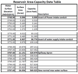
The model of the reservoir terrain is analyzed for to generate area and capacity values for each surface elevation value. This process creates a table of values that can be imported by your hydrologist into your software system. 
Creating a new rating curve using Drone collected aerial imagery and photogrammetric processing is very cost effective when compared to the cost of a bathymetric sonar survey and airborne LiDAR terrain survey.